
PFO Night & DayHurstwood South RegionalSun 04 December, 2022
Regional level event
Explanation of Event levels
- Training events are non competitive events used for training and coaching, aimed at members of the club, but they can attract people from neighbouring clubs, and are often ideal for newcomers to try the sport.
- Local events are usually low key and in the 'localised' area, ideal for newcomers to try the sport. Most clubs run some 'mini series' throughout the year as local mid week events.
- Regional events attract participants from around the local Region.
- National events are high quality competitions that will attract people from far away,
- Major events are Major Events such as a British Championships or the annual JK competition.
Results
Report
Controller's comments: (Posted on both the Saturday NWNL and the Sunday Regional event pages.)
Well done all the PFO volunteers for delivering successful parking, starts, finishes and downloads, and thanks to all the brave souls who took on December weather and a very complex area, especially in the dark.
However, things were made much harder than they needed to be by several of the maps being printed at inappropriate scales - and manifestly this made a huge difference to the enjoyment levels for many people. I can only apologise for not challenging the various scale choices being made on your behalf - with legible maps I'm sure everyone would have enjoyed the technical difficulties available. It seems to me that the hushings areas can be thought of as solid sand dunes, and as such conventional large scales and even possibly 2.5m contours would give you a fighting chance of map-reading your way through them. It is a great shame that Stephen's efforts in coming up with good use of the terrain on offer were compromised in this way.
Also apologies to Short Green folks who didn't enjoy their uphill slog near the end. In the absence of a Very Short Green several people would have been very happy to stop at that point, and probably a better solution to getting more distance would have been a "map exchange" and two trips through the good stuff.
Also apologies to Orange folks for a gratuitous hack through the tussocks at control 110. This control wasn't meant to be there - but when permissions were lost for the big field, there wasn't time for tagging and checking and somehow the circle ended up on a fence corner that wasn't the one intended.
And a special mention for Judith Wood, who happily joined me on several bad-weather outings and was an invaluable help.
Two specific issues:
> several people remarked on physical-ness and tussocks. GIven the tussock areas were clearly distinguished on the map and pretty accurately mapped, I suspect some of these complaints were from people who hadn't appreciated the need to forgo straight lines and instead adopt tussock-avoidance lines. In general I thought Stephen had done a decent job of minimising the unavoidable tussocks.
> The Night Green had an extraordinary number of wrong #9 mispunches. There were two pools of water -144m apart according to ppen. One was contained in rectangular brick walls, the other just a pool disappearing into a culvert - and both had kites, though the rectangular pool's kite was highly visible and it appears the smaller pool's kite wasn't. Both the map and the control descriptions had a rectangle or not as appropriate. It seems that people weren't checking their control codes and had misjudged distance travelled (albeit easily done in the dark). Very disappointing all round, but I don't think the planning could be considered unfair.
And a couple of general comments on Night events:
> the shiny white paper NW clubs are using these days can be tricky with bright headlights. I struggled last week at Longsight Park, and a tip I was given afterwards was to hold the map at a slight angle so reflections don't come straight back. Something NW folks are going to have to get used to.
> a few controls were close to patches of white in rough open. In perfect light it can be hard to make out the boundaries; at night it is pretty much impossible. Maybe yellows should be specially darkened for night events.
John Britton MDOC - Controller.
Planner's comments:
Despite the chilly weather we had a good turnout over the two days and the feedback was generally positive, it seemed like the more experienced runners appreciated the balance between running legs and navigational challenge and also my best efforts to avoid the worst of the tussocks! Those newer to the sport enjoyed the progression offered from park/urban events and got to experience one of our most technical areas at its (cold) best.
The main issues experienced seemed to be around the night map. The competition map itself was as used for the SHI in 2018 with a few minir updates, so it has been checked in competition and there shouldn’t have been any problems with accuracy. From feedback, a larger scale would have been better for some competitors, especially at night - this isn’t a complaint that we have previously had with courses here, but is definitely something that we can change for future events. There were comments about paper ‘glossiness’ and contrast between colours (rough open yellow in contrast to white woodland) which seem to be pretty widespread issues at night events. There are also some of the harder problems to solve, considering the wide range of sizes and colours of lights (what is acceptable to a runner with a whiter light can be more difficult for a runner with a yellower light) and the effect of the glossiness of the map itself is dependant, on the strength of the head torch.
Despite this, it seemed the vast majority of competitors left happy (but tired!).
All that remains is to thank everyone who made the weekend a success and especially the many PFO volunteers and helpers. Thanks too to Joh Britton for his many visits to the area and for his guidance.
Stephen Horrocks PFO - Planner.
Organiser's comments:
Thanks to all of you who both competed and helped last weekend: a very technical area to negotiate in the biting cold of December and particularly at night.
One of my main concerns was the speed of traffic along the main road and unfortunately, we were obliged to park cars along the verge for both events. I hope that the number of volunteers, the flashing hazard warning lights and signage made it as safe as it could be.
PFO is a relatively small club and over the two events, the 20 or so volunteers worked very hard, some doing a ’double shift’ and most managing to compete too. I did question whether it is fair to ask club members to work over both days and to do more than one job in wintry weather conditions, but felt it was necessary to cover all areas safely. I would welcome your comments but thank you all so much for all your help.
Thanks are also due to Bridget Jardine who negotiated at length for permission to use the area, part of which is an S.S.S.I and overseen by Natural England. The tenant farmer, Michael Holmes, kindly arranged to move his livestock, so that courses could be run over some of his fields. We are also indebted to Anne and Sandra Mitton whose field we used for 4x4 parking and toilet facilities, (provided by Valley toilets of Clitheroe) and the DC Coffee van, which was arranged at the last moment and was very welcome.
My job was made significantly easier because of support from Helen Ashton and George Crawford-Smith and as a club, we are very grateful once again for the mentoring of John Britton, our Controller and to the Planner, Stephen Horrocks, assisted by Graham H and Judith W.
Finally, I feel an apology is due to Dave and Dawn, who had to witness my incompetence, whilst trying and failing to put the Pop- up tent back in its bag and then had the injustice of carrying the unrestrained article back to the Download area. Surely a training opportunity there?!
Helen Smethurst - Organiser
RouteGadget
Is a web browser app for sharing and comparing orienteering routes. You can draw your own route or upload a GPS track from your watch. It also allows you to watch an animated replay with a simulated mass start.
Go to the Pendle Forest Routegadget now
Hurstwood South is a classic long distance Regional event. Challenging navigation guaranteed.
Safety: This is a winter event over high exposed moorland - WHISTLES and WATERPROOF JACKETS are MANDATORY and must be worn or carried - unless specifically relaxed by the controller. To cope with wind, rain and cold, carrying hats, gloves, additional thermal layers and waterproof trousers may also be necessary. Be prepared!
Mobile phones may be carried as a safety measure only. Emergency help numbers will be printed on your competition map.
Respect the fundamentals of orienteering and do not use your phone as a navigational aid, except if you have retired.
Water courses: Recent heavy rain has left the ground saturated. Most streams are very minor, but those in the valley bottom may be very full if rain falls in the days before the event. Watch for advice notices and always take great care when crossing.
Retirement: If retiring, proceed either to the main track that bisects the area or to the large water pipeline, both of which run north-south. Follow these south to reach the public car park and Download. You MUST report your retirement to Download.
Control descriptions: They will be on the map and available as loose descriptions in the start lanes.
Permissions:
We are indebted to Natural England (SSSI), United Utilities (landowner) and Michael Holmes (tenant farmer) for permission to use the area.
The previous evening, Saturday 3rd December, there will be the NWNL Hurstwood South night event using some of the same area.
Location Info

Near: Mereclough, Burnley Lat,Lng: 53.75762,-2.16697 OS Grid Ref: SD893288 Postcode: BB10 4RR
Open an interactive map in:
GoogleMap -
Streetmap (OS 50k)
OpenStreetMap -
BingMap (OS 50k)
Directions / Parking
Would all vehicles please follow this route of approach, so that everyone is arriving at the event from the same direction: From the T-junction at BB10 4SP on the A646 (signed from here), follow Red Lees Lane (keeping left at Overtown, avoiding a very steep and narrow lane) to the Kettledrum pub (BB10 4RQ). Turn right in front of the pub on to the Long Causeway. Follow this (steeply uphill at first) for 2 miles to parking.
Parking will be adjacent to the Long Causway. Navigate to BB10 4RR or What3Words ///drag.messaging.stocky
This road is straight and undulating and locals often drive fast along it. Take great care and signal when slowing down to park. Park as directed. Children must be accompanied.
Due to recent rain the parking field is not suitable for 2-wheel drive vehicles. You will be directed as follows: 4x4 vehicles to the field and 2-wheel drive vehicles to the road verge on the northern side of the road only. Park half-on and half-off the verge for safety.
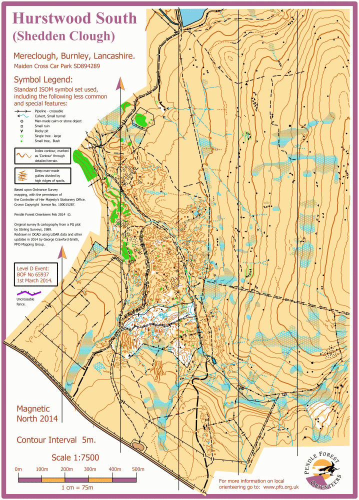
Map / Terrain
Hurstwood North is the area used for the SHI and National events in 2018, with its lunar dune-scape.
Hurstwood South, however, is characterised by limestone hushings comprised of large gullies and spoil tips. The hushings are surrounded by classic Pennine moorland of variable runability. An adjacent area, not previously used for orienteering, has been added to the map.
Registration and Start times
On-line pre-entry only via SIEntries. Online entries will remain open, via SIEntries, until the first start time on race day, but only up to the number of spare maps available. Cash EOD entries cannot be accepted.
Start times from 10:30 to 12:00.
Courses close at 14:30PM
Course Information
Regional Courses:
| Course: | Length: | Climb: | Controls: | Map: |
| Brown | 8.8k | 360m | 24 | A3 1:10000 |
| Blue | 6.2kk | 270m | 17 | A3 1:10000 |
| Green | 4.3k | 160m | 18 | A4 1:10000 |
| Short Green | 3.0k | 155m | 12 | A4 1:10000 |
| Light Green | 3.7k | 125m | 15 | A4 1:7500 |
| Orange | 3.0k | 120m | 14 | A4 1:7500 |
| Yellow | 2.9k | 60m | 11 | A4 1:7500 |
To Start: 900m undulating. From Finish 650m uphill.
Hired dibbers can be collected at Download.
Courses Orange, Light Green and Green have to climb over locked 5-bar field gates. There won't be stiles to help.
All courses, except Short Green, will travel along the line of a significant pipeline, which is metal, approx 1m in diameter and exposed in a few stretches. It could be very slippy in places, so take appropriate care.
Entry Details
Online only via SIEntries.
Standard entry has now closed, but see below for last minute entries.
Adults (M/W21+) £10.00 (Non-BOF £12.00)
Juniors (M/W20-) £4.00 (Non-BOF £5.00)
Dibber hire £1.00 but £40 if lost! Collect hired dibbers from Download.
Late entry now open via SIEntries until 4th December (race day) at 10:30AM (first start time), but only up to the number of available spare maps.
Adults (M/W21+) £12.00 (Non-BOF £14.00)
Juniors (M/W20-) £4.00 (Non-BOF £5.00)
Cash EOD entries cannot be accepted.
Dog restrictions
This is sheep country - no dogs permitted on courses.
Facilities
Portable toilets in the 4x4 parking field, opposite dibber issue and Download.
DC Coffee mobile cafe will be in attendance and parked in the 4x4 parking field. Treat yourselves to a freshly brewed winter warmer!
Take great care when crossing the road. Observe marshal's instructions. Children must be accompanied.
Apres drinks and food available in Mereclough village at the Kettledrum (about 2 miles from parking), Red Lees Road, BB10 4RQ. Pre-booking for the restaurant is advised as it is popular at the weekends. Other hostelries are available.
(Nino's at the Fighting Cocks, is now closed for the winter.)
Miscellaneous
For general enquiries -
BOF event: 76578
Contacts / Officials
Planner: Stephen Horrocks PFO
Controller: John Britton MDOC
Organisers: Helen Smethurst PFO & Helen Ashton PFO