
Spring Series, event 3/4Calf Hey RegionalSun 13 April, 2025
Regional level event
Explanation of Event levels
- Training events are non competitive events used for training and coaching, aimed at members of the club, but they can attract people from neighbouring clubs, and are often ideal for newcomers to try the sport.
- Local events are usually low key and in the 'localised' area, ideal for newcomers to try the sport. Most clubs run some 'mini series' throughout the year as local mid week events.
- Regional events attract participants from around the local Region.
- National events are high quality competitions that will attract people from far away,
- Major events are Major Events such as a British Championships or the annual JK competition.
Results
Report
Controller’s Comments
I hope you enjoyed your run at Calf Hey tackling the quality courses produced by Judith. The aim was to give competitors a mix of different terrains and technicality, rewarding people who could quickly adapt to a changing situation. I thought the planning was excellent, both fair and interesting. Course time ranges were good and there was only a 7% retirement rate. Most comments were positive and I personally did not get any “you ruined my day” type rants from anyone! Little wins...
Planning: At first glance, Calf Hey appears to be an easy area to plan on. But once you look at it more closely there are a number of complicating factors. Top of these are the 3 valleys which are either out of bounds or have dangerously steep sections that are unsafe to cross. You might have thought we chose tricky crossings for these but believe me these were some of the safest ones! Not crossing them would have ruled out over a third of the area so it led to some compromises on control positions and route choice. I also steered Judith away from using the steep open area with deep heather south of the reservoir as I have always hated running in that in previous races.
Fences: Apologies if we caused a bit of confusion with whether it was ok to cross fences or not. I took the view that use of 'discretion' when crossing fences or walls was OK. However, this got lost somewhat in translation. It was tricky as there were some fences (e.g. wood or broken) that were easily crossable that I had hoped to tempt as a route choice. We planned courses to avoid high fence crossings being the clear optimal route and I was against covering the map with purple overprint, since the valleys were the bigger problem. Difficult to capture this nuance but hopefully it did not take away from the enjoyment of your run.
TD3/4 courses: Some competitors struggled with the rough moorland in the SW of the map. Although rich in line features it is difficult terrain to cross which led to a few big time losses here. Again, apologies if it took away from your enjoyment of the course.
Development: Whilst a good area, Calf Hey is quite restricted for planning longer courses. It quickly became apparent that a brown course was not a serious option. Even the short brown was light on length and involved some contrived loops to achieve the distance. For those not aware, Calf Hey is part of the larger Haslingden Grane area used by SELOC (see Routegadget 2 ). To the immediate SE of Calf Hey is Musbury Quarry that has 0.5+km² of top quality terrain that would add a lot of value to the TD5 courses. However, this has not been used in 10 years. When checking controls I went to one of the crossing points and looked across at the quarry and how easy it would be to link the areas. With this small section added, a top quality brown would be easily achieved. It would be great to find a solution to get this area back into use as Calf Hey and Musbury Quarry would make a super area.
Steve Wilson PFO
RouteGadget
Is a web browser app for sharing and comparing orienteering routes. You can draw your own route or upload a GPS track from your watch. It also allows you to watch an animated replay with a simulated mass start.
Go to the Pendle Forest Routegadget now
This is a Regional event and the third of four in our Spring Series.
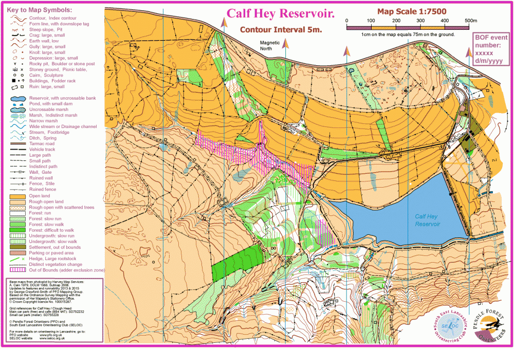
Calf Hey is an attractive area with a good mix of terrain including coniferous and deciduous forest, open moorland, old field network and mineral extraction pits, showing remnants of it's old industrial past. Challenging at all levels and a great orienteering area for the north-west. A full range of courses from Short Brown through to Yellow (families). There is also a Red course for those wishing to have a longer run out, but at intermediate level, great for club/fell/trail runners.
Location Info

Near: Haslingden Lat,Lng: 53.70391,-2.37836
Open an interactive map in:
GoogleMap -
Streetmap (OS 50k)
OpenStreetMap -
BingMap (OS 50k)
Directions / Parking
Event centre: Within the grounds/adjacent to Clough Head Visitor Centre.
W3W: ///soggy.parsnips.fountain
Parking: Parking will be in fields at Clough Head information centre/cafe.
Park as directed. Please do not park in the public cafe car park (that you will pass through) unless you have small children or mobility needs.
W3W: ///soggy.parsnips.fountain
Address: Clough Head car park, 461 Grane Rd, Haslingden, Rossendale BB4 4AT.
Should the need arise, overflow parking will be in two wide lay-bys approximately 250m west of the main car park entrance (staggered lay-bys on either side of the road). The road here is wide but busy, so do take care walking on the verge back to the Event Centre.
Map / Terrain
The Calf Hey map is 1:7500 for all courses.
Calf Hey is a really attractive area with a good mix of terrain including coniferous and deciduous forest, open moorland, old field network and mineral extraction pits. Challenging at all levels.
There are cattle in the field areas to the north and west of the competition area and have freedom to roam most of this area. They have never been a problem in the past. You may see none, but if cattle are encountered, to avoid disturbance, please give them a wide berth. We recommend at least 25m.
Map notes:
1). One large area of woodland has within it a patchwork of fallen trees due to old age and/or windblow. Areas that are easily traversed, though slow, are shown with the wide green pinstripe symbol. Areas that are very slow or impassable are shown with the narrow pinstripe symbol - best avoided!
2. There are several streams that run is chasms that may be up to 10m deep! Instead of the usual blue line, streams in these areas are marked with a wide purple line to indicate the stream is uncrossable. Steep terrain on either side must also be avoided. Take great care.
Only cross streams where they are blue on the map.
Registration and Start times
Start times from 11:00 to 12:30. When entering, choose your 15 minute start block.
Courses close at 14:30.
Please choose an early start time if you anticipate being out for a long time.
Cafe closes at 16:30.
Parking closes at 17:00.
Course Information
Courses:
| Course | Length | Climb | Notes |
| Short Brown | 6.5 km | 310 m | 21 controls, TD5 |
| Blue | 5.4 km | 250 m | 18 controls, TD5 |
| Green | 3.9 km | 150 m | 14 controls, TD5 |
| Short Green | 3.1 km | 100 m | 13 controls, TD5 |
| Light Green | 3.2 km | 160 m | 12 controls, TD4 |
| Red | 4.2 km | 180 m | 18 controls, TD3 |
| Orange | 2.5 km | 80 m | 11 controls, TD3 |
| Yellow | 1.7 km | 60 m | 11 controls, TD2 |
Start & Finish: Distance from Event Centre approximately 1km / 10m climb .
You will be crossing a busy main road before and after your run. The crossing will be marshalled. Young children MUST be accompanied.
Stockproof walls and fences must only be crossed at nominated crossing points or at natural breaks.
Entry Details
On-line pre-entry only via SIEntries. No EOD.
Standard pricing will apply up to midnight Wednesday 9th April. Entry will remain open after this, subject to map availability, until midnight Friday 11th April, with a late entry surcharge of £2.00 Adults / £1.00 Young Adults & Juniors.
Entry fees for BOF-members:
| Senior (26+) | Young Adult (21-25) | Junior (U21) | |
| Up to 09/04/2025 | £9.00 | £6.50 | £4.00 |
| From 10/04/2025 | £11.00 | £7.50 | £5.00 |
Entry fees for non-members:
| Senior (26+) | Young Adult (21-25) | Junior (U21) | |
| Up to 09/04/2025 | £11.00 | £8.00 | £5.00 |
| From 10/04/2025 | £13.00 | £9.00 | £6.00 |
Dibber hire £1.00 (£40 if lost/broken). Hired dibbers must be collected from Download at the Event Centre before heading to the Start.
Dog restrictions
This is sheep and cattle country - absolutely no dogs on courses. Dogs may be exercised after the event on leads. Doggy etiquette please.
Facilities
Near to the event centre:
- Clough Head Cafe.
- Public Toilets.
Note: Cafe closes at 16:30; Parking locked at 17:00.
Miscellaneous
General enquiries:
BOF event number 86066
Contacts / Officials
Planner: Judith Wood PFO.
Controller: Steve Wilson PFO.
Organiser: Hannah Dabinett PFO.