
Holcombe RangesSun 16 December, 2018
Regional level event
Explanation of Event levels
- Training events are non competitive events used for training and coaching, aimed at members of the club, but they can attract people from neighbouring clubs, and are often ideal for newcomers to try the sport.
- Local events are usually low key and in the 'localised' area, ideal for newcomers to try the sport. Most clubs run some 'mini series' throughout the year as local mid week events.
- Regional events attract participants from around the local Region.
- National events are high quality competitions that will attract people from far away,
- Major events are Major Events such as a British Championships or the annual JK competition.
Report
Results
Simple results and splits
RouteGadget
Event photos for both Night and Day: Marcus Schmidt of TSG Weisloch (near Heidelberg) orienteering club competed on both the Night Blue and the Day Blue courses. As he was "on holiday" at the time and not competing for UK ranking points he took many photos of the courses.
See TSG Weisloch Facebook link or cut and paste: https://www.facebook.com/TSG-Wiesloch-Orientierungslauf-1682398888710145/
Controller's Comments:
Storm Deirdre tried to put us off, but failed! In fact Sunday dawned fair and calm though cold. Night and day controls on the range proper had already been put out on the Saturday so it only remained to add the high moorland controls early on Sunday. We were treated to a beautiful sunrise with low cloud drifting away for the scarp tops. Thanks are due to Judith for her challenging courses and to Bridget for masterminding the camp security plan (complimented by the camp guard!) and the best parking and registration you could wish for.
Judith's day courses made full use of the very varied terrain: natural woodland, contour detail, river crossings (too many for some), old mining detail, rough open slopes and, for the long courses, fast open moorland with pinpoint navigation required. Everyone was complimentary.
To summarise: Judith delivered first class courses, with no controlling issues at all, in a highly varied area and run by top class orienteers. 2 seconds under 1 hour as the winning time for Brown 8.5k/285m (@ 7m/k) is going some!
We want to make you aware of the higher than normal entry fee which was occassioned by the additional access fees levied by the MOD for use of their area over and above our normal costs. We think the area warrented the extra. We hope you agree
Well done to all helpers and thanks to a all competitors for rewarding all involved with your complimentary comments. Thanks too to the MOD, Greater Manchester ACF and Natural England for access permission.
George Crawford-Smith PFO - Controller.
Organiser's Comments
I would like to give a big thank you to the landowners and other parties for allowing us to use the area for both the night and day events, Landmarc, The National Trust and Natural England were all very helpful in bringing together the licencing for the event. I also need to give a very big thank you to Greater Manchester Army Cadet Force for the use of their training centre. The use of the White House, giving us heated indoor facilities for registration and download, as well as the use of kitchen facilities was a real bonus. Car parking was made very easy as we were able to use the tarmac car park, with overflow available if we had needed it. Access to toilets was also much appreciated.
The events seem to have been well received, I have not been made aware of any negative comments but plenty of positive ones – which is always gratifying. This must have been helped by the excellent planning and controlling by Peter, Judith and George.
The weather played its part, Saturday was very cold with freezing rain making the preparation for the event interesting, the conditions underfoot were treacherous and did cause us some concern. Surprisingly the rain decided to clear and for the majority of the actual event it didn’t rain. Sunday started with mist on the tops but this later cleared to give a nice sunny day – though cold. We still had concerns about ground conditions as there were patches of ice and all stones were very slippery. I am not aware of anyone hurting themselves for which I am grateful. I hope you all enjoyed yourselves.
I would also like to say thank you to the PFO members who gave up their time to help with the events over the weekend, it wasn’t the best of weather and all did a sterling job in keeping everything running as planned.
Thank you.
One item of lost property – a black glove – XXL, Quechua. Found in the registration room. Please get in touch with me if this is yours.
Bridget Jardine PFO - Night & Day Organiser.
Pre-event info below here:
===========================
Important: Holcombe Ranges is an active MOD training ground. PFO must account for all competitors arriving and departing from the camp. Download the security form in Downloadable Documents below: Fill it in (vehicle reg, driver, passengers) and hand it in to the PFO marshal at the gate. This will speed your entry into, and exit from, the camp.
Holcombe Ranges Day Event: EOD only.
We are privileged to have access for our event, for which we must thank the MOD for their permission. Our thanks go to the National Trust and Natural England for permission to use an extended part of the competition area.
The Holcome Range area is untouched by the usual commencial land uses so the mix of woodland and rough open has a very natural feel. This is a fantastic area with challenging navigation - well worth the visit.
Permission for Holcombe Ranges is not easy to obtain and this is a rare opportunity to orienteer here. The date has been chosen to avoid live firing! Enjoy!
WARNING: Do not handle any unusual objects you may find in the area, however you should report their whereabouts to Registration.
Safety: This is a winter event - WHISTLES and WATERPROOF JACKETS are MANDATORY - unless specifically relaxed by the controller. Carrying hats, gloves, additional thermal layers and waterproof trousers may also be necessary. Be prepared.
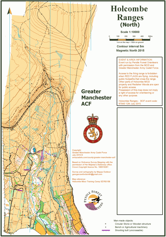
The orienteering map is at a scale of 1:10000 for Brown and Blue courses (including a newly mapped adjacent area) and 1:7500 for other courses. Military objects such as flag poles and notice boards plus isolated trees in open areas are not shown. Fences should only be crossed at stiles and gates. Crosssing symbols designate traditional stiles, gates and a large number of military roll-over crossing points. All are marked on the map and should be used. The high and barbed wire topped Range perimeter fence must only be crossed at marked points.
The previous night, Saturday 15th, there will be a NWNL Holcombe Ranges Night event using the same parking and registration. Night Orange, Green and Blue courses.
Other previous events on the Range are the Northern Night Champs in 1972, a small part used for CAPRICORN 2013 using a 1:25000 OS extract and PFO's Regional in 2015.
RouteGadget
Is a web browser app for sharing and comparing orienteering routes. You can draw your own route or upload a GPS track from your watch. It also allows you to watch an animated replay with a simulated mass start.
Go to the Pendle Forest Routegadget now
Location Info

Near: Ramsbottom, Lat,Lng: 53.63974,-2.35910 OS Grid Ref: SD763158 Postcode: BL8 4JJ
Open an interactive map in:
GoogleMap -
Streetmap (OS 50k)
OpenStreetMap -
BingMap (OS 50k)
Directions / Parking
Access to the camp is between Ramsbottom and Hawkshaw on the A676 Bolton Road. Turn north into Spenleach Lane (20mph obligatory speed limit),. Signed from this junction.
Entry forms will be available at this point. Use the parking area to complete the form before proceeding to the main gate.
You must observe the speed limit of 20 mph on Spenleach Lane. There are occasional speed bumps!
At the camp entrance gate hand in your form to the PFO marshal declaring vehicle number and occupants/age class/club . This will speed your entry and exit from the camp.
Drive through the camp to hard-standing parking area. Park as directed. Registration will be less than 100m, or 300m if overflow parking is required. There will be no parking charge.
Registration will be in one of the camp meeting rooms..
Registration and Start times
Please do not arrive before 9:30AM.
Registration/Enquiries: From 10:00AM to 12:00AM.
Starts: From 10:30AM to 12:30PM. Open start times.
Courses Close: At 2:30PM.
Course Information
| Course: | Length: | Climb: | Notes: |
|---|---|---|---|
| Brown | 8.5k | 285m | 17 controls, 1:10000 map, inc new area |
| Blue | 5.3k | 215m | 13 controls, 1:10000 map, inc new area |
| Short Blue | 4.7k | 165m | 11 controls, 1:7500 map |
| Green | 3.4k | 160m | 11 controls, 1:7500 map |
| Short Green | 2.8k | 75m | 11 controls, 1:7500 map |
| Light Green | 3.0k | 120m | 12 controls, 1:7500 map |
| Orange | 2.5k | 85m | 9 controls, 1:7500 map |
| Yellow | 2.2k | 60m | 8 controls, 1:7500 map |
| White | Area not suitable |
Open start times.
Distance from Registration to Start is 400m.
Control descriptions on waterproof paper at the Start only.
Distance from Finish to Download/Registration is 300m.
Safety: The competition area is partly exposed open land. All courses cross this area. In the event of wet, cold or windy weather the Controller may insist on competitors carrying waterproof hooded tops. Be prepared - bring them with you. Carrying whistles is advised.
Fences: Fences within the competition area are quite high and many are topped with barbed wire. Use one of the many marked crossing points, gates or stiles. One unusual feature of the area is squaddy roll-over fence crossing points, which are half-round wide wooden fence-tops which can be rolled over even with a heavy pack. They are marked on the map with the ) ( symbol. Your course line may not be directed to a specific point, so choose at will.
The perimeter fence of the range is 5 ft tall and topped with barbed wire. It is marked on the map as a high fence and should not be crossed at any point other than at the optional marked crossing points.
River crossing: The main stream through the centre of the Range can be swollen after heavy rain. There are some bridging points in the lower reaches, but upstream there are none. Take care crossing, as rocks in and around the streams are very slippery.
Emergency Phone: If you are minded to carry a mobile phone (there is some signal in some places) the event official help numbers are 07482 775081 or 07813 320936.
Entry Details
EOD only .
Adults (M/W21+) BOF members £9.00 (non-members £11.00)
Juniors (M/W20-) BOF members £4.00, (non-members £5.00)
Dibber hire £1.00, but £40.00 if lost!
Dog restrictions
Updated 6/12/2018: It is a condition of the MOD licence that NO DOGS are brought on to the site. This is a change from previous information.
Facilities
Toilets at Registration/car park.
First aid provided by members of PFO. Details of nearby emergency care centres will be available at Registration.
Contacts / Officials
Planner: Judith Wood PFO, Controller: George Crawford-Smith PFO, Organiser: Bridget Jardine PFO