
PFO Night & DayNick o'PendleSun 05 December, 2021
Regional level event
Explanation of Event levels
- Training events are non competitive events used for training and coaching, aimed at members of the club, but they can attract people from neighbouring clubs, and are often ideal for newcomers to try the sport.
- Local events are usually low key and in the 'localised' area, ideal for newcomers to try the sport. Most clubs run some 'mini series' throughout the year as local mid week events.
- Regional events attract participants from around the local Region.
- National events are high quality competitions that will attract people from far away,
- Major events are Major Events such as a British Championships or the annual JK competition.
Results
RouteGadget
Is a web browser app for sharing and comparing orienteering routes. You can draw your own route or upload a GPS track from your watch. It also allows you to watch an animated replay with a simulated mass start.
Go to the Pendle Forest Routegadget now
Pre Event Info
This event, was originally planned for December 2020, then re-scheduled for January 2021, but due to ongoing Covid lockdown, was eventually cancelled and entry fees refunded.
This Regional event is paired with the North West Night League event taking place the previous night.
Covid and Omicron varient: Please observe social distancing throughout this event and bring a mask with you to wear in social settings before or after the event. Start procedure, as far as possible, will be one competitor starting per minute.
Safety: This is a winter event - WHISTLES and WATERPROOF JACKETS are MANDATORY and must be worn or carried - unless specifically relaxed by the controller. To cope with wind, rain and cold, carrying hats, gloves, additional thermal layers and waterproof trousers may also be necessary. Come prepared!
Mobile phones may be carried as a safety measure only. Help numbers, which will be printed on your competition map, are 07549 534300 or 07947 323809. Respect the fundamentals of orienteering and do not use your phone as a navigational aid, except if you have retired.
Control descriptions: They will be on the map and available as loose descriptions in the start lanes.
Permissions:
We are indebted to Clitheroe Estates, the landowners, for permission to use the area.
The previous evening, Saturday 4th, there will be the NWNL Nick o'Pendle event using some of the same area. However, parking will be at a different location.
Location Info

Near: Clitheroe Lat,Lng: 53.84665,-2.34657 OS Grid Ref: SD773389 Postcode: BB7 9HN
Open an interactive map in:
GoogleMap -
Streetmap (OS 50k)
OpenStreetMap -
BingMap (OS 50k)
Directions / Parking
If you can travel with others and thereby reduce vehicle numbers, that will be helpful.
The main parking zone will be hardstanding or roadside, on the north side of the Nick, at and around the Wellsprings Restaurant and the adjacent Pendle Ski Club, BB7 9HN.
Space is limited, so please park as directed and do not leave large gaps from the vehicle in front or beside you.
Early arrivals will be parked in the Wellsprings car park. Later arrivals will be roadside. There is limited space for campavans, so arrive early or come by car!
Approaching along the A59 is the easiest route from both the M6 (from south, west or north) or via Skipton (from east). Turn off the Clitheroe bypass at the roundabout, signed for Sabden. After you cross the cattle grid watch out for parking marshals who will direct you to a suitable roadside parking spot on your left or direct you to the hardstanding. Turning round is difficult.
From the south there are numerous routes, but all pass through Sabden village. From there, cross the Nick and descend to the parking area. There is roadside parking on your left before the Wellsprings (about 8 to 10 cars) and also after the Ski Club (about 6 to 8 cars). If all areas on your left are full, you should continue downhill through the cattle grid, then make a safe U-turn in the corner layby on your left, so that you are travelling back uphill to park on your left.
Single drivers approaching through Sabden might prefer to park where space permits before crossing the Nick, then walk roadside (do not enter the competition area) to the flagged route to the Start. 10 minutes walk max.
What3words coordinate is /// formal.liver.ushering which will place you near the Wellsprings car park entrance.
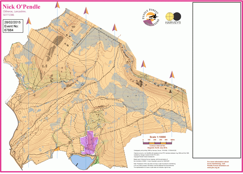
Map / Terrain
The competition area comprises all of the open land between the Nick o'Pendle road and Ogden Clough. It is high and exposed. Height from 200m to 450m and there is little or no shelter, so come prepared - see clothing notes above.
Typically the area is rough open grassland, with peat in places, that is mostly runnable. There are patches of slower vegetation, including bracken (wide green pinstripe symbol) which should be low and passable at this time of year. There are many landform and rock features which are evidence of historic mineral extraction. There is one major stream but many marshes, ponds, ditches and gullies.
Marked paths are through routes that actually go somewhere! Stock tracks and minor 'dog walkers' paths are generally not marked.
Registration and Start times
There is NO EOD and NO Registration. See below for pre-enter details.
Early Start Times from 9:30 to 11:30. Start times are one hour earlier than usual so that most competitors will arrive at parking earlier than the general public.
Courses close at 14:00.
Course Information
Course details:
| Course: | Provisional Length: | Provisional Climb: | Technical difficulty: Map: |
| Brown | 8.5k | 315m | TD5, 1:10000, A4 |
| Blue | 5.3k | 285m | TD5, 1:10000, A4 |
| Short Blue | 4.8k | 195m | TD5, 1:10000, A4 |
| Green | 3.9k | 190m | TD5, 1:7500, A4 |
| Short Green | 3.2k | 130m | TD5, 1:7500, A4 |
| Light Green | 3.1k | 140m | TD4, 1:7500, A4 |
| Orange | 2.8k | 95m | TD3, 1:7500, A4 |
| Yellow | 2.3k | 100m | TD2, 1:7500, A4 |
The area is not suitable for a White course.
Control descriptions will be on the map and available in the Start lanes.
Hired dibbers can be collected at Download, situated near to roadside parking opposite Pendle Ski Club.
Route to the Start will be flagged from Download. (Allow 5 minutes, 300m and 40m climb.)
Route from Finish will be flagged to Download.
Entry Details
Pre-entry only via SIEntries:
Opens on 18th October and closes at midnight on 1st December or earlier if we reach our maximum of 120 competitors.
Select your 10 minute start window when you register.
Seniors (M/W21+): BOF £8.00, Non-BOF £10.00
Juniors (M/W20-): BOF £3.00, Non-BOF £4.00
Dibber hire £1.00, but £40 if lost!
Dog restrictions
No dogs. This is sheep country.
Facilities
You will be parking at or near The Wellsprings Restaurant. The outside Cafe is unfortunately closed at this time, however the restaurant is open from 12:00 noon till 7:45PM on Sundays. Inside there is a cafe area and restuarant, plus toilet facilities for patrons only.
We are very grateful to Pendle Ski Club for the use of their Ladies and Gents toilets in their club house. Open from 9:00AM till the end of our event.
As a courtesy to both, please carry a face covering in case either establishment is crowded.
Miscellaneous
BOF event number 79177
Contacts / Officials
Planner - Peter Stobbs PFO
Controller - Andy Quickfall SROC
Organiser - Judith Wood PFO