
Spring Series (4/4)Peel Park, AccringtonSun 31 March, 2019
Regional level event
Explanation of Event levels
- Training events are non competitive events used for training and coaching, aimed at members of the club, but they can attract people from neighbouring clubs, and are often ideal for newcomers to try the sport.
- Local events are usually low key and in the 'localised' area, ideal for newcomers to try the sport. Most clubs run some 'mini series' throughout the year as local mid week events.
- Regional events attract participants from around the local Region.
- National events are high quality competitions that will attract people from far away,
- Major events are Major Events such as a British Championships or the annual JK competition.
Results
Report
Maureen Ashton has written to thank everyone who bought cakes and/or preserves at Registration. £220 was raised and will be donated on your behalf to Rosemere Cancer Foundation in Preston. We are most grateful.
Controller's Comments:
Working with planner Max was an easy task, as his courses needed no modifications from me (apart from the situation of having 36 controls on the original Brown course, and consequent dibber capacity problem!) Max's rejig of the course meant less controls, longer and more challenging legs and satisfaction from competitors. All courses were well received, which is very gratifying, so thank you all for your attendance and helpful comments.
Jim Mitchell PFO - Controller.
Planner's Comments:
Planning an event on this area is a bit of a challenge due to the size of the area and the vegetation. I was very lucky to have Jim and George at hand to help with advice and guidance. The courses were planned to give a selection of route choices on as many of the legs as possible and minimise the chance of covering the ground more than once. I also added plenty of climb to add the physical element to you route choice decisions. I am glad we had such a nice day for the event and to see so many happy faces.
Max Cole PFO - Planner.
Organiser's Comments:
The good turnout of skilled and dedicated PFO volunteers made this event a ‘piece of cake’ to organise (did someone mention cake?) and contributed to a great family atmosphere that everyone seemed to enjoy.
There was also a great turnout of runners, despite this being both Mothers’ Day and the day that clocks went forward. The brown course seemed particularly popular, and we printed a few spare maps on the day, but in the end we had just enough.
Our major worry was whether we would fit all the happy orienteers into the car park as parking in the surrounding streets was limited. Then, like the sun breaking through the clouds, we discovered that we also had access to a second parking area within the school grounds. This easily coped with the numbers.
Throughout the day there was a great atmosphere and bunting bedecked picnic benches were full of orienteers enjoying cakes, flapjack, scones, jams and lemon curd from Maureen’s cake stall.
Sunshine, orienteering and CAKE! What more could anyone want?
Lee Gosling PFO - Organiser.
RouteGadget
Is a web browser app for sharing and comparing orienteering routes. You can draw your own route or upload a GPS track from your watch. It also allows you to watch an animated replay with a simulated mass start.
Go to the Pendle Forest Routegadget now
Pre Event Info
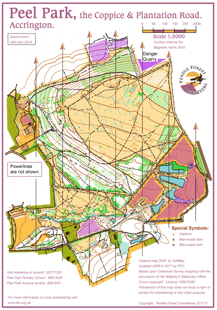
Using both the Coppice and Plantation areas.
Don't forget - British Summer Time begins today!
Classic colour coded courses from Yellow to Brown for all orienteers. The area offers a wide variety of terrain for all abilities.
The whole competition area (Park, Coppice, Plantation and open moor) is popular with runners, dog walkers, horse riders, mountain bikers and orienteers. As a consequence you may encounter unmapped incidental paths. Please give way to other users.
The mill workers park and the Coppice were bequeathed by William Peel to the people of Accrington town in 1909, with the scarp of now mature conifers being planted in 1972/3. The curious maze of ditches on the top moor were dug by Italian POWs in WWII as a defence against Luftwaffe gliders landing. They were entirely successful in this endeavour, but unwittingly bequeathed some novel navigation to later generations. Plantation Road was where the mill owners great houses once stood by a cobbled highway.
Location Info

Near: Accrington Lat,Lng: 53.75780,-2.35509 OS Grid Ref: SD766290 Postcode: BB5 6QR
Open an interactive map in:
GoogleMap -
Streetmap (OS 50k)
OpenStreetMap -
BingMap (OS 50k)
Directions / Parking
Easiest approach is from the A56 junction with the A679. From here follow Burnley Road towards Accrington centre. After 1 mile (just before a set of traffic lights) turn left into Alice Street (signed from here) then left into the Peel Park School parking area (£1 donation please) and Registration. Or satnav to BB5 6EW.
If the off-street parking (in Peel Park Primary School grounds) is full please find on-street parking in the many side streets off to the right from Alice Street. Please do not park on Alice Street itself as this is a busy thoroughfare.
Map / Terrain
Peel Park comprises a very small area of easy parkland with large adjacent areas of woodland and rough meadows, scrubland, becks, ponds and old mine workings to add interest.
The Coppice is the coniferous plantation on the hill scarp which offers open running. Above this is open moorland with an unusual pattern of ditches.
The Plantation area is mostly young deciduous woodland with old ruins and contour features.
The whole area, which is criss-crossed by an extensive path network, gives great variety at both easy and technical orienteering standards.
Registration and Start times
Registration from 10:00 to 12:00
Starts from 10:30 to 12:30.
Courses close at 14:00.
You can save time by downloading the EOD entry form below. Fill it in and present at Registration.
Course Information
| Course | Length | Climb | Notes |
|---|---|---|---|
| Yellow | 1.9 km | 80m | TD2. A4 |
| Orange | 2.4 km | 80m | TD3. A4 |
| Light Green | 2.9 km | 115m | TD4. A4 |
| Short Green | 3.5 km | 125m | TD5. A4 |
| Green | 3.9 km | 155m | TD5. A4+ |
| Short Blue | 4.5 km | 185m | TD5. A4+ |
| Blue | 5.8 km | 275m | TD5. Double sided map. A4+ |
| Brown | 8.0 km | 340m | TD5. Double sided map. A4+ |
The map is 1:5000 printed on waterproof Pretex paper. The A4+ size is to accommodate the control descriptions. There is no symbol legend on the map, but loose copies are available from Registration. Loose control descriptions in the start lanes. Blank maps will be displayed at Registration and in the Start lanes.
There are four special or new symbols on the map:
- 'X' = man-made object = old gate way
- 'O' = man-made object = concrete drain cover
- open brown triangle = platform
- blue 5 pointed star = drain pipe outflow
Power lines ARE shown on the map.
Entry Details
EOD entries only: EOD form can be downloaded and completed in advance. See below.
BOF members: Adults £7.00, Juniors £3.00
Non-BOF competitors: Adults £9.00. Juniors £3.00
Dibber hire £1.00, but £40 if lost.
Dog restrictions
No dogs during the competition. They may be exercised in the competition area after your run.
Do not allow dogs to foul in the school grounds. There is a walking route near to Registration and parking. Please use this area and pick up after your dog.
Facilities
Portaloo Toilet at Registration.
There will be a home made produce and cake stall in aid of Rosemere Cancer Foundation in Preston. Two club members, who have recently been treated here, would like to continue supporting their good works.
Should you require post-event refreshment, the Peel Park Hotel/Pub is just 100m from parking/registration. In addition to the usual pub offering they serve tea, coffee and snack meals (including pie & peas).
Miscellaneous
There is no legend on the map.
If you need a copy, please ask for a copy at Registration, or save and print the GIF image on this event web page.
Contacts / Officials
For general enquiries -
Organiser: Lee Gosling PFO
Planner: Max Cole PFO
Controller: Jim Mitchell PFO