
Lancashire HotPot ClassicPendle HillSat 11 September, 2021
Regional level event
Explanation of Event levels
- Training events are non competitive events used for training and coaching, aimed at members of the club, but they can attract people from neighbouring clubs, and are often ideal for newcomers to try the sport.
- Local events are usually low key and in the 'localised' area, ideal for newcomers to try the sport. Most clubs run some 'mini series' throughout the year as local mid week events.
- Regional events attract participants from around the local Region.
- National events are high quality competitions that will attract people from far away,
- Major events are Major Events such as a British Championships or the annual JK competition.
Results
Report
Controller's Comments:
"My thanks to PFO for inviting me to Control. An interesting area!I received very few negative comments on Max's courses or the map. Maybe some courses were a tad long (eg. Short Blue?), and some longer-course folks suggested climb had been understated. Probably the area turned out less runnable than I'd expected - I'd thought gravity assistance would help, but apparently not, though I still think using a high start was a good idea.
People who struggled didn't manage to decide which of the ground shapes were the groughs on the map, but I think most of that was unfamiliarity with areas like this and maps at that scale. Even on my first visit I felt I could make sense of it. Most people seemed to point the compass and hope to tick off the groughs, but I'm not convinced that was always the best approach.
Most competitors navigated their course successfully, though 12% mis-punched or retired. Quite a high rate though understandable in this tough terrain, with so little to relocate off."
John Britton MDOC - Controller.
Organiser’s Comments:
‘Mist Over Pendle” by Robert Neill is a 1951 novel of witchcraft and retribution. Early arrivals for the Pendle Hill HotPot must have given a little shudder, or perhaps a wry smile, at the sight before them … mist over Pendle! At 9AM visibility at the Start was 50m, but the mist burnt back by first starts and no one was subjected to blind navigation.
Max Cole’s planning, control sites and courses were spot on, by all accounts, but anyone losing contact with the map found relocation tricky! Seasoned orienteers, with a moorland mindset, romped around in respectable times.
Organisationally, the long climb, the Start, the Finish and Parking being far apart, with semaphore communication, lead to special arrangements to ensure that everyone who started was properly accounted for at the end. John Britton MDOC (Controller) asked for an extra dibbing “Hill Check” in Barley so that the results team would get early notification of who had set foot on the hill. The Hill Check box was delivered to Download half-an-hour before the last Start time. No one got lost in this tricky area, no one was injured, and there was just one retirement!
As far as I am aware, the self-park arrangements Barley, worked OK. I trust no one will receive a parking fine for doing a runner from the village car park. I hear that some (many?) competitors enjoyed the hostelries of Barley. All good we presume.
Thank you to Max and John for staging such challenging courses. Also, many thanks to the legion of PFO helpers on the day, early runs, late runs, putting up, taking down, collecting in and more besides. Too many to name individually, but you know who you are. Hats off!
George Crawford-Smith – Organiser.
RouteGadget
Is a web browser app for sharing and comparing orienteering routes. You can draw your own route or upload a GPS track from your watch. It also allows you to watch an animated replay with a simulated mass start.
Go to the Pendle Forest Routegadget now
Pre Event Info
Classic long distance.
Open fell orienteering.
Control descriptions and a map of the Route to the Start are available to download in the 'Facilities' section below.
Location Info

Near: Burnley, Barley Lat,Lng: 53.85854,-2.27021 OS Grid Ref: SE823402 Postcode: BB12 9JX
Open an interactive map in:
GoogleMap -
Streetmap (OS 50k)
OpenStreetMap -
BingMap (OS 50k)
Directions / Parking
Kerbside parking on The Avenue, Barley Road and Barley New Road (this is all one road running east from Barley village). What3Words coordinate: ///buying.montage.wrist
The road is now marked with double yellow lines at gateways, road bends and passing places. Do not obstruct
Parents with children may prefer to use the off-road Barley Village Car Park at £3.00 for 3 hours or more. Proceeds go to the village. Number plate recognition. Pay on exit at 'kiosk'
This is a very popular location on good weather days. Early arrival will ensure that you can park reasonably close to the village.
Map / Terrain
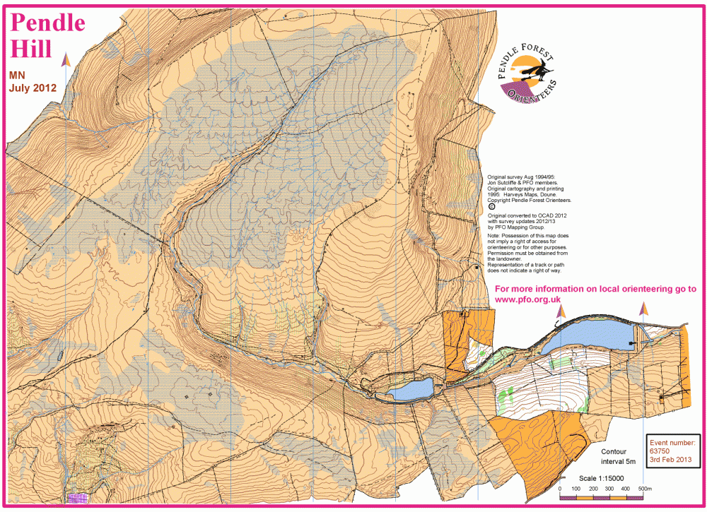
Updated map. Some parts not previously used for orienteering.
Pendle Hill is rough open moorland with lots of intricate contour and drainage detail. A mix of peat and light grassland in the upper reaches, with rough grassland at mid height and progressively more vegetation in the lower reaches.
There is one long boundary fence that divides the competition area. Longer courses will cross this fence. It is sturdy and made of wire mesh with a plain wire top (not barbed) and varies in height from 80cm to 120cm. It may be crossed at any point, though fence corners or one of the 10 optional crossing points marked will be easiest. The crossing points may be gates, through stiles or a ladder.
There is no legend on the map. A legend sheet can be downloaded in the Facilities section below.
Special symbols:
'O' large, with dot, black = Large cairn > 1.5m, Trig point or Monument
'o' small, with dot, black = Small cairn, Pile of stones (low) or Boundary stone.
'X', black = Man made object e.g. Large bench, Hide or abandoned Farm machinery
'X', green = Large rootstock > 2m high
Registration and Start times
There is no Registration. On-line entry only via SIEnties.
Entries close at midnight on Wednesday 8th September.
First starts 10:30. Last starts 12:00 noon.
We recommend that you set off walking between 45 and 60 minutes before your start time. You will not be turned away from the Start if you arrive early or late.
Courses close at 14:00.
Course Information
HotPot COURSE OFFER: You may enter any course but for head-to-head competition by age class we have suggested courses by M/W age categories.
Final course details:
Control descriptions can be downloaded by course in the "Facilities" section below.
| Course: | Length: | Climb: | Suggested Age Classes: | Technical difficulty: Map: |
| Black | 8.9k | 150m | M21 | TD5 A3, 1:10000 |
| Brown | 7.9k | 135m | M18 M20 M35 M40 M45 M50 W21 | TD5 A3, 1:10000 |
| Blue | 6.6k | 130m | M16 M55 M60 W35 W40 | TD5 A3, 1:10000 |
| Short Blue | 5.2k | 105m | M65 W18 W20 W45 W50 | TD5 A4, 1:10000 |
| Green | 4.8k | 10m | M70 W16 W55 W60 | TD5 A4, 1:10000 |
| Short Green | 3.1k | 5m | M75+ W65+ | TD5 A4, 1:7500 |
| Light Green | 3.7k | 90m | M14 W14 | TD4 A4, 1:7500 |
| Orange | 2.9k | 50m | M12 W12 | TD3 A4, 1:7500 |
| Yellow | 2.8k | 15m | M10 W10 | TD2 A4, 1:7500 |
Control descriptions will be available to download in the week before the event.
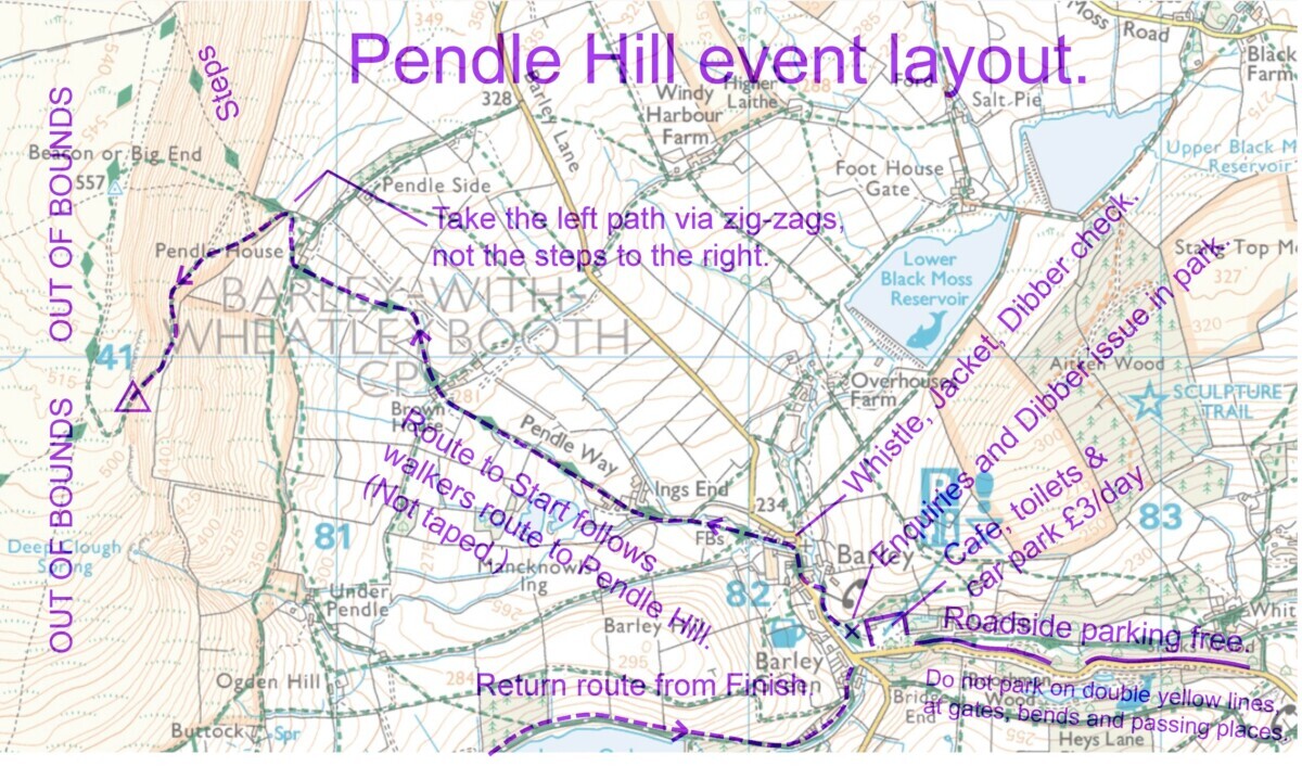
The route to the Start (2.1k and 275m climb) follows the well marked regular path to the top of Pendle Hill, but breaks off left when you reach the open fell. Signed from this point. Walking time is typically 40 minutes at an average pace. There is no clothing transfer, so you must take your protective clothing with you on your run.
The return to parking from the Finish (1.0k downhill) will take about 10 to 15 minutes.
SAFETY: The event area is exposed with little shelter anywhere. Whistles and waterproof, hooded jackets MUST be carried, unless specifically relaxed by the Controller.
In the event of retirement, there is no one safety bearing, therefore you must make your way to the nearest downhill path and follow it to Ogden Clough and the path that leads to two reservoirs. You MUST report to the Finish/Download by the lower reservoir, so that we know you are safely off the hill.
Alternatively, make your way downhill, following any water run-off channel (blue-dash symbol) which will also take you to Ogden Clough. Follow this, or the long boundary fence, as above.
As an additional safety measure you may also carry a mobile phone. Be aware that reception is poor, though better on high ground and non-existent low down. Texting the emergency number will be more reliable than a voice call. The number is 07813 320936 as shown on your map.
Entry Details
Pre-entry only via SIEntries.
When choosing a start block, be aware that the walk to the Start, fast/average/slow, is 30/40/50 minutes .
Entries close at midnight on Wednesday 8th September.
Adult BOF £10.00, non-BOF £12.00
Junior (M/W20- and full time students) £4.00, non-BOF £4.00.
Dibber hire £1.00. Collection point will be near the car park/cafe/toilets. Not at Download, which will be at the Finish.
Dog restrictions
No dogs on courses. This is sheep country.
Facilities
Public toilets and cafē in the village car park. There is also a pub, tea rooms and restaurants in Barley village.
Note: There is no cover at the Start. Go before you set off.
A symbol legend sheet can be downloaded here.
Download control descriptions below:
Black
Brown
Blue
Short Blue
Green
Short Green
Light Green
Orange
Yellow
Route to the Start map below:
PH 2021 Barley parking and routes
Miscellaneous
General enquiries -
Covid19: The latest advice from British Orienteering entitled 'Return to Orienteering (England)' dated 19th July, can be downloaded here.
It recommends safe working practices which PFO will be practicing and recommend to all participants.
BOF event code: 76980
Contacts / Officials
Planner Max Cole PFO
Controller John Britton MDOC
Organiser George Crawford-Smith PFO