
River Darwen RegionalSat 01 November, 2025
Regional level event
Explanation of Event levels
- Training events are non competitive events used for training and coaching, aimed at members of the club, but they can attract people from neighbouring clubs, and are often ideal for newcomers to try the sport.
- Local events are usually low key and in the 'localised' area, ideal for newcomers to try the sport. Most clubs run some 'mini series' throughout the year as local mid week events.
- Regional events attract participants from around the local Region.
- National events are high quality competitions that will attract people from far away,
- Major events are Major Events such as a British Championships or the annual JK competition.
Results
RouteGadget
Is a web browser app for sharing and comparing orienteering routes. You can draw your own route or upload a GPS track from your watch. It also allows you to watch an animated replay with a simulated mass start.
Go to the Pendle Forest Routegadget now
This is a Regional event.
River Darwen Parkway & Higher Croft Woods is a new orienteering area.
The competition area is split north-west to south-east by the Blackburn to Bolton and Manchester railway line. The competition area is about 1 mile from the main Blackburn rail station, so arrival by train is easily possible. e.g half houly service from Manchester.
Location Info

Near: Blackburn Lat,Lng: 53.72960,-2.48838
Open an interactive map in:
GoogleMap -
Streetmap (OS 50k)
OpenStreetMap -
BingMap (OS 50k)
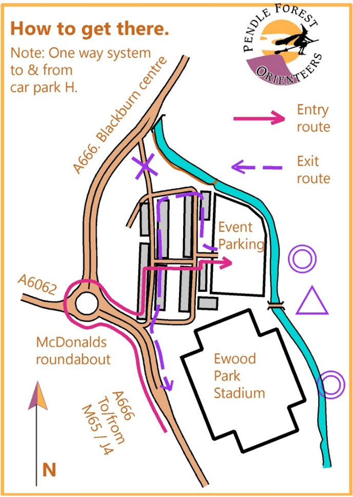
Directions / Parking
Event centre: Car Park H, Blackburn Rovers, Ewood Park stadium. (PFO event day is NOT a home match day.)
Parking: Car Park H is a charged car park managed by ANPR.
A discounted parking rate of £3 (covering up to 10hrs) has been agreed with the football club. Payment must be made online via a special link here.
All drivers must provide their vehicle registration number when making payment.
Please note that late payment (departing prior to payment) may result in a substantial fine, as the car park is monitored by ANPR (Automatic Number Plate Recognition) cameras.
🚫 Important: Scanning the QR code displayed in the car park, will charge the full day rate instead of the discounted event rate!
Please note, the entrance/exit route is via a one way system in a residential area. The entry/exit routes are shown here.
PostCode: BB2 4JA (nearest location)
What3Words: ///start.donor.under
Map / Terrain
Map notes:
The event map for all courses is 1:7500, double sided, printed on A4 waterproof paper.
West of the rail line is mostly woodland on the slopes and banks of the River Darwen. To the east there are mixed areas of open ground and woodland, and further east again is Highercroft Woods, a deep wooded valley, reached only by the longest courses. All areas have a well-trodden path network, plus urban areas with multiple route choices.
The new map was first surveyed in 2024, using the latest ISOM symbols, which includes symbol 105.200 "Retained earth wall" of which there are several examples on the map. (The symbol is the same as for a "retained wall" but printed in brown, not black.)
Terrain notes:
In addition to the very runnable path network and urban areas, there is woodland and rough open land where you may will encounter some seasonal undergrowth that has not yet fully died back. These rough areas have variable runnability and spikiness!
Some footbridges and board-walks have been damaged. Take care to step over missing or fire damaged boards. They will NOT be taped.
Clothing:
Competitors on ALL courses should wear long legwear. Shorts are NOT recommended.
Orienteering studded shoes are best for this mixed terrain, which is steep in places.
Railway crossings:
There are 6 railway crossing points shown on the map. Some are bridges over, some are bridges under and one is a low tunnel (mind your head!). All are optional and clearly marked.
Registration and Start times
Start times from 11:00 till 12:30. When entering, choose your 15 minute start block.
Courses close at 14:30.
Please choose an early start time if you anticipate being out for a long time.
Course Information
All courses are printed on double sided A4. Turn your map over at the map-flip control as indicated in your control descriptions.
Courses:
| Course | Length | Climb | Notes: |
| Short Brown | 6.4km | 160m | 23 controls, TD5, Map flip at 17. |
| Blue | 5.9km | 115m | 20 controls, TD5, Map flip at 12. |
| Green | 4.1km | 85m | 15 controls, TD5, Map flip at 4. |
| Short Green | 3.2km | 85m | 13 controls, TD5, Map flip at 5. |
| Light Green | 3.2km | 65 m | 11 controls, TD4, Map flip at 6. |
| Red | 5.9km | 115m | 15 controls, TD3, Map flip at 10. |
| Orange | 2.8km | 55m | 10 controls, TD3, Map flip at 6. |
| Yellow | 2.0km | 40m | 10 controls, TD2, Map flip at 5. |
Start & Finish: Distances from Event Centre.
Start: Approximately 150m.
South Finish (Red & Light Green only): Approximately 300m.
The return route has short steep sections, which may be slippery when wet – take extra care.
North Finish (All other courses): Approximately 150m.
Entry Details
On-line pre-entry only via SIEntries. No EOD.
Standard pricing will apply up to midnight Wednesday 29th October. Entry will remain open after this, subject to map availability, until midnight Friday 31st October, with a late entry surcharge of £2.00 Adults / £1.00 Young Adults & Juniors.
Entry fees for BOF-members:
| Senior (26+) | Young Adult (21-25) | Junior (U21) | |
| Up to 29/10/2025 | £9.00 | £6.50 | £4.00 |
| From 30/10/2025 | £11.00 | £7.50 | £5.00 |
Entry fees for non-members:
| Senior (26+) | Young Adult (21-25) | Junior (U21) | |
| Up to 29/10/2025 | £11.00 | £8.00 | £5.00 |
| From 30/10/2025 | £13.00 | £9.00 | £6.00 |
Dibber hire £1.00 (£40 if lost/broken). Hired dibbers must be collected from Download at the Event Centre before heading to the Start.
Dog restrictions
Dogs are permitted under control. Please clear up after your dog.
Facilities
Portable toilets will be available in the car park.
There will be no on-site catering. There is a McDonalds across the main road about 4 minutes walk away from parking. Other eateries are available in town or at the M65/J4 service station.
Miscellaneous
General enquiries:
BOF event number 86914
Contacts / Officials
Planner: George Crawford-Smith PFO.
Controller: Judith Wood PFO
Organiser: Hannah Dabinett PFO