
RegionalTockholesSun 08 December, 2024
Regional level event
Explanation of Event levels
- Training events are non competitive events used for training and coaching, aimed at members of the club, but they can attract people from neighbouring clubs, and are often ideal for newcomers to try the sport.
- Local events are usually low key and in the 'localised' area, ideal for newcomers to try the sport. Most clubs run some 'mini series' throughout the year as local mid week events.
- Regional events attract participants from around the local Region.
- National events are high quality competitions that will attract people from far away,
- Major events are Major Events such as a British Championships or the annual JK competition.
Results
Report
Lost Property - black Geldert cagoule left in the download tent
RouteGadget
Is a web browser app for sharing and comparing orienteering routes. You can draw your own route or upload a GPS track from your watch. It also allows you to watch an animated replay with a simulated mass start.
Go to the Pendle Forest Routegadget now
POST EVENT Reports:
Planner's Comments:
Having started planning unsure what was in store, the event(s) turned out very well in the end. It was great to see a good turnout and such a wide variety of experience, from those attending their first event at Tockholes, to those whose Tockholes history goes back a few decades!
Courses were well received, despite having some pretty technical controls from the very beginning and feedback was almost universally positive. The only remaining thing is to thank the many volunteers, without whom events like this wouldn’t happen at all. Thanks especially to Andy Quickfall for Controlling, George for Organising and Peter for coordinating the various put-out teams (for both night and day, all put out on Saturday).
Hopefully we'll see you all at another PFO event soon!
Stephen Horrocks, PFO
Organiser's Comments:
Well, that was fun! Organising two events on successive days, the NW Night League event and the day Regional. My thanks to all PFO members who put a days work to make this event a success. Thank you all.
We encountered two major problems, which I trust we resolved to your satisfaction:
- The parking arrangements, Normally we use John Smith's field for parking, but with all the autumn rainfall, this was out of the question, except for the 4x4 vehicles.
We decided on roadside parking, despite the obvious potential dangers. It worked well but used up a number of extra volunteer PFO members to ensure that everyone parked sensibly and safely. It worked. We ended the day with half-a-dozen spare spaces. - Storm Darragh, for scences of destruction elsewhere, see https://www.bbc.co.uk/news/articles/c0mvv4d014ko
We (Controller, Organiser and deputy planner Peter Stobbs) agreed earlier in the week to make the final GO/NO GO decision on Saturday c.1:00PM, giving us just enough time to contact participants to change or keep their journey plans.
Our decision was GO night / GO day, not on the basis of the weather warning (it had been OK putting out in the morning (no rain and quite calm in the woods), but on the basis of whether it was safe to cross the main stream/river. Water levels can rise and fall very quickly here and to our relief they were low and the stream fordable in many places of your choosing.
Many competitors actually thanked the team for going ahead with the event despite the dire weather warnings. The biggest difficulty in the woods turned out to be the muddy/marshy and leaf stewen terrain, not the objective dangers of falling tree branches or difficulot crossings.
To cut a long weekend story short, EVERYONE enjoyed their "well planned" courses through some very runnable and tehnical terrain with interest all the way. No wonder Tockholes has been used for orienteering since the very beginning of O-time in Egland, circa 1966. England World Cup year.
PFO are happy to be custodians of the forest and hosts to all orienteers in this very lovely area. Come again!
George Crawford-Smith, PFO.
Mappers notes:
I hoped you liked the new map of Tockholes. The previous version was drawn with the aid of Lidar data, on to which we have completely resurveyed the vegetation. There are many patches of holly that were previously mapped, in a very general way, as a sigle shade of green. Current mapping tools (tablet with GPS) enable sketching amendments to be made directly onto the previous map version, then uploaded back to the map in OCAD for editing. The end resuolt is a much improved repressentation of singular, linear and area featurs and runnability. I hope your found the resultant map to be easy to understand.
I received only one complaint: The scattered bushy area around 117 (Night: Blue and Day: Brown, Blue and Short Blue.) was difficult to interpret on the run, partly because some of the veg change symbol was partly obscured by the control circle for 117 and partly because of the complex nature of the large and small bushes within the veg change. I found it difficult to map, so shall try and get that rectified before our next event.
PS: You can orienteer at Tockholes Woods any day, on your own, or with your children/grandchildren/other by loging on to the GOORIENTEERING website at https://www.goorienteering.org.uk/course/Tockholes and downloading the POC (Permanent Orienteering Course) maps. Confusingly the area is called Roddlesworth on this website, as it is the water company (landowners) name for the reservoirs and surrounding area that we, as orienteers, have known as Tockholes for decades. You can download an Easy, Medium or Hard course, either to your phone or for printing. Good luck!
=========================================================
Pre-event info below here:
5/12/2024 LATE NEWS: The weather forecast for the weekend is not great, though no worse than we have all experienced at other events previously. The Controller and Organiser will be assessing the terrain and streams on the Saturday morning before the night event. A decision will be made whether to go ahead or to postpone the event(s).
This decision will be communicated to all participants early on Saturday afternoon, so you have time to alter your travel plans if necessary.
Please check your inbox as notification will be sent by email to all participants and not via this website.
Note also some extra safety information in the Course Information section.
Safety: This is a winter event - WHISTLES and WATERPROOF JACKETS must be carried or worn - unless specifically relaxed by the controller. To cope with wind, rain and cold, carrying hats, gloves, additional thermal layers and waterproof trousers may also be necessary. Be prepared!
Mobile phones may be carried as a safety measure only. Emergency help numbers will be printed on your competition map.
Respect the fundamentals of orienteering and do not use your phone as a navigational aid, except if you have retired.
Retirement: If retiring, proceed to the east of the competition area to the Tockholes road. Follow this to the venue. You MUST report your retirement to Download.
Control descriptions: They will be on the map and available as loose descriptions in the start lanes.
Permissions: We are indebted to United Utilities (landowner) for permission to use the area.
Location Info

Near: Blackburn Lat,Lng: 53.68658,-2.50909
Open an interactive map in:
GoogleMap -
Streetmap (OS 50k)
OpenStreetMap -
BingMap (OS 50k)
Directions / Parking
5/12/2024 LATE NEWS: The parking field, as used for many previous events is very wet. Chevron parking off the main hard core track will be for 4x4 vehicles only. A marshal will guide you. Two-wheel drive cars and vans will be parked roadside nearby. 2 wheels off the road and 2 wheels on the road. Please arrive via the A675 (see below) so that all vehicles are facing north and the verge you will be parking on will be on your left. Take great care when leaving your vehicle as other road users may be travelling fast.
We are asking for a donation (£2 suggested) for each vehicle parked. Please have coins available. The money goes to good causes in Tockholes village, so even if you are parked roadside, the village will appreciate your contribution. There will be a collection bucket.
==================
Field parking near to BB3 0PA. However using W3W ///reveal.aquatics.buckling will take you to the entrance gate of the parking field, which is approximately 500m south of the Tockholes Information Centre/Rambler's Country Cafe and Royal Arms car park, all of which will be open on the day.
Best approach from north, east and west is via the M65. Exit at J3 and follow the A675** for (7km/4.5mi) past Tockholes Woods on your left to the next minor junction left, signposted Tockholes. Proceed for 2.0km/1.25mi, to the parking field entrance gate, which will be an easy turn on your right. Follow parking marshals directions. Your donation per vehicle (recommended £2) goes to local good causes in Tockholes. The alternative route via J4 through Tockholes Village is steeper, bumpier, twistier and slower - and is not recommended.
** Average speed cameras are in operation on the A675: from J3, first 50mph, then 40mph, then 30mph through Abbey Village and then 50mph.
From the south (Bolton direction) follow the A675 through Belmont village (average speed cameras in operation) then after 2.5k/1.6mi turn right at the junction noted above, then 2.0k/1.25mi tp parking.
Anyone bringing a large camper van or larger coach should contact the Organiser in advance for details of alternative parking.
Map / Terrain
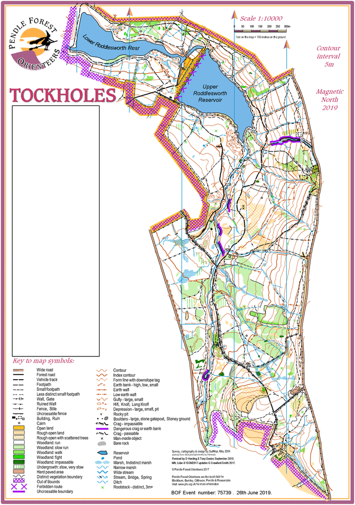
Tockholes has been used for orienteering for more than 50 years! It is excellent mixed terrain that is 90% woodland.
High quality orienteering terrain in mature woodland around the catchment area of Roddlesworth Reservoirs. Map updated 2024.
Tockholes has been used for orienteering for over 50 years! Much has changed in that time, but the woods, a mix of deciduous and coniferous woodland, remains largely clear of nasty undergrowth and is very runnable. There is no forestry grid and no straight lines anywhere, but there are ample rock, forest, landform and water features. Quality orienteering guaranteed!
The area is popular with walkers, dog owners, runners and mountain bikers – take care and give way.
As such there are many incidental paths and tracks, in places too numerous to map. Only the main and through paths are marked.
Several high crags and a dangerous ravine are highlighted with the purple uncrossable symbol along the top edge. Some crags are 10m high! Beware!
Registration and Start times
Start times from 10:30AM to 12:00 noon. When entering choose your start time in one of 4 x 15 minute blocks.
Courses close at 14:00PM.
If demand is suficient start times and course closing times will be extended by half an hour.
Course Information
Course Offer: (Provisional.)
| Course: | Length: | Climb: | Controls: | Notes: |
| Brown | 7.9k | 250m | 22 | TD5. Map 1:10000 |
| Blue | 6.1k | 150m | 16 | TD5. Map 1:10000 |
| Short Blue | 5.1k | 135m | 15 | TD5. Map 1:10000 |
| Green | 4.4k | 115m | 12 | TD5. Map 1:7500 |
| Short Green | 3.4k | 85m | 12 | TD5. Map 1:7500 |
| Light Green | 3.1k | 80m | 8 | TD4. Map 1:7500 |
| Orange | 2.3k | 70m | 10 | TD3. Map 1:7500 |
| Yellow | 2.3k | 50m | 9 | TD2. Map 1:7500 |
Distance to the Start is 200m from parking and the return from the Finish is 600m.
Control descriptions will be on the map and available as loose descriptions in the start lanes.
Safety Notes:
- Slippery underfoot: The ground is saturated after more than usual autumn rain, so many parts are muddy and waterlogged. Also the ground is covered with autumn leaves which obscure minor paths and and other features.
Please take great care. Wear only O-shoes with good cleats. DO NOT wear flat soled trainers. - Dangerous high crags and earth banks: Marked as uncrossable using a thick purple line along the top edge. Some crags are 10m high!
There are also deep ravines with steep sides. If marked with an earth bank symbol, then the ravine will be unsafe to cross at that point.
Some side streams have carved a deep furrow that may be more than 1m deep and more than 1m wide. Take great care if crossing such a stream. - River crossings: Advice will be given on the Start line. There are 3 options to choose from at your discretion:
- Foot bridges (3 marked on the map as a crossing point). Unaffected by water levels.
- Easier fording points (3 marked on the map as a crossing point). Depending on water levels a handrail rope may be fixed to trees on both banks.
- When water levels are low, it is possible to ford at many points. (No crossing points marked.) Cross safely at your discretion.
Entry Details
On-line pre-entry only via SIEntries. No EOD.
Standard pricing will apply up to midnight Wednesday 4th December. Entry will remain open after this, subject to map availability, until midnight Friday 6th December, with a late entry surcharge of £2.00 Adults / £1.00 Young Adults & Juniors.
Entry fees for BOF-members:
| Senior (26+) | Young Adult (21-25) | Junior (U21) | |
| Up to 04/12/2024 | £9.00 | £6.50 | £4.00 |
| From 05/12/2024 | £11.00 | £7.50 | £5.00 |
Entry fees for non-members:
| Senior (26+) | Young Adult (21-25) | Junior (U21) | |
| Up to 04/12/2024 | £11.00 | £8.00 | £5.00 |
| From 05/12/2024 | £13.00 | £9.00 | £6.00 |
Dibber hire £1.00 (£40 if lost/broken). Hired dibbers must be collected from Download before heading to the Start.
£1.00 Discount per person if entering both the day and nights events.
Dog restrictions
No dogs on courses. You may exercise your dog in the woods, under control, after your run. Please remember that this is sheep country. Do not let your dog run loose in the parking field.
Facilities
Toilet cubicles at Parking.
The Ramblers Country Cafe and the Royal Arms pub are both 500m north of event parking. Both serve food and drink and will be open at the time of this event, however the cafe closes at 3:00PM.
In addition, those competitors leaving to rejoin the M65 at J3, will pass through Abbey Village. Holden's (cafe, bakery and icecream parlour) on your left as you travel north, is open on Sundays. Worth a visit!
Miscellaneous
General enquiries -
BOF event: 83439
Contacts / Officials
Planner - Stephen Horrocks PFO
Controller - Andy Quickfall SROC
Organiser - George Crawford-Smith